About
Maider Llaguno-Munitxa (MLLM) is an architect and associate professor at the Faculty of Architecture, Architectural Engineering and Urban Planning (LOCI), and Louvain Lanscape Architecture and Built Environment (LAB) Institute at UCLouvain. Maider is the leader of the urban science, climate and health team within the Architecture et Climat group at LAB UCLouvain. Her research work focuses on the study of data science and digital design tools for the development of novel design practices that aim to improve urban environmental quality and health.
Prior to joining UCLouvain, Maider was an assistant professor at the School of Architecture at Northeastern University, and associate research scholar and postdoctoral researcher at the department of Civil and Environmental Engineering at Princeton University where she worked on the formulation of data driven urban environmental design processes. Maider is also partner at the architecture and urban design office AZPML. Maider obtained her PhD from the Institute of Technology in Architecture ETH Zurich in October 2016. Her research topic focused on the study of architecture and urban design strategies to modulate the urban environment, it's microclimate and air quality. Maider has been recently recipient of the SOM Foundation European Research Prize, GSAPP Columbia University incubator prize, and the Land Der Ideen_Beyond Bauhaus Prototyping the Future Award. Maider has been the awardee of numerous research funding grants from the European Commission, the FNRS, Princeton University, and the Research Unit of the Brussels-Capital Region, amongst others.
Prior to her PhD studies, in 2010 Maider graduated with -excellence in design- in Advanced Architecture Design from The Graduate School of Planning and Preservation, at Columbia University in New York City, and from the Escuela Tecnica Superior de Arquitectura de San Sebastian (ETSASS) -Seneca program at the Escola Tecnica Superior de Arquitectura de Barcelona (ETSAB)- in Spain from where she received her Diploma in Architecture with honours in 2006.
From January 2007 until June 2009 Maider worked at FOA (Foreign Office Architects), where she was involved in numerous international competitions and in the detail design of the Trinity EC3 office complex and the Ravensbourne College of Art and Communication in London. In 2012, she co-founded AZPML architecture.
Maider has been teaching extensively both in the US and Europe. She has taught at GSAPP Columbia University, at the ETH Zurich Institute of Technology in Architecture, the visiting school program of the Architectural Association in London, and Yale school of architecture in New Haven amongst others.
Her fields of knowledge include architecture and urban design, computational design, data science, urban physics, and building physics. The work of Maider Llaguno-Munitxa has been published in various international architectural periodicals and newsletters as well as in scientific journals focused on the topics of environmental sciences and design computation.
Over the past 14 years, Maider's work has focused on studying urban and building information models, and environmental phenomena, to develop innovative design practices aimed at improving urban environmental health. The following sections include work samples developed in the last four years during her time at UCLouvain, as well as during her PhD and postdoctoral research.
Recent News
DECEMBER 2022 - DECEMBER 2024 | SKIDMORE OWINGS AND MERRILL FOUNDATION PRIZE - PROJECT Air de Jeux
Team: M.Llaguno-Munitxa C.Cavalieri, B.Lamparielo, C.Fontain, G.Ledent, D.Claeys, G.VanMoeseke
The Air de Jeux project, led by UCLouvain-LOCI-LAB professors in collaboration with Les Chercheurs d’Air, the VUB, BuildWind, and BCR municipal representatives, focuses on designing and developing a school street into a play street aimed at enhancing the environmental well-being of children.
In Fall 2023, students in a master's course at UCLouvain–LOCI-LAB proposed urban environmental installations for a case study on a school street in Saint-Gilles, BCR. A jury of academics, environmental experts, and public officials selected a proposal that critiqued the management of school streets, highlighting that children were not fully benefiting from street closures or the potential to transform these spaces into play areas. The proposal suggested extending street closure times and reducing vehicle speeds using mobile urban micro-infrastructures. The design incorporated reconfigurable fabric elements to encourage play and interaction. In Spring 2024, a workshop at UCLouvain's Saint-Gilles campus involved students building the installation using reused materials, with hands-on metalworking and fabric design under expert guidance. Parallel workshops at École Peter Pan engaged primary school students in exploring the street and providing feedback. By summer 2024, the installation was completed, and it was inaugurated on September 13th on Rue de la Rhétorique.

JUNE 2020 - JUNE 2021 | COLUMBIA UNIVERSITY GSAPP INCUBATOR PRIZE : CLIMATE, HEALTH, & CITIES - PROJECT URBAN MICROENVIRONMENTS
Environmental inequity is one of the most critical contemporary urban challenges. The death rates from the pathogenic respiratory disease SARS-CoV-2 virus have shown disconcerting spatial patterns disproportionally affecting low income neighborhoods which are often environmentally most disadvantageous. Through mobile urban sensing technologies, we have also recently learnt that within an urban block distance, the air quality conditions can get up to 8 times worse. The project - Urban Microenvironments -. compiled datasets on the physical attributes, socioeconomic metrics and environmental parameters for the cities of New York and Los Angeles. The project proposed comparative visualizations of the most advantageous and disadvantageous areas of the city in terms of urban environmental health conditions placing a particular attention on air pollution exposure and heat stress.
SUMMER 2021 | VENICE BIENNALE ITALIAN VIRTUAL PAVILION - PROJECT EVERY ENVIRONMENT
Every environment is an urban environmental information visualization research that pays homage to Ed Ruscha’s 1956 photography series called Every Building on the Sunset Strip, where systematic and continuous street-view documentation through mobile image capturing allowed for a new mode of urban mapping.
Every environment focuses on the continuous image-based visualization of two of the most critical urban environmental inequity parameters: urban greenery and air pollution. Through the application of direct and remote sensing, machine learning and computer vision analysis, the green fraction and PM2.5 concentrations have been computed and visualized, aiming to highlight the hidden and nuanced environmental gradients that characterize the main circulation arteries in cities. This piece displays the case study of Broadway Avenue in Manhattan, New York City. Project in collaboration with Biayna Bogosian.
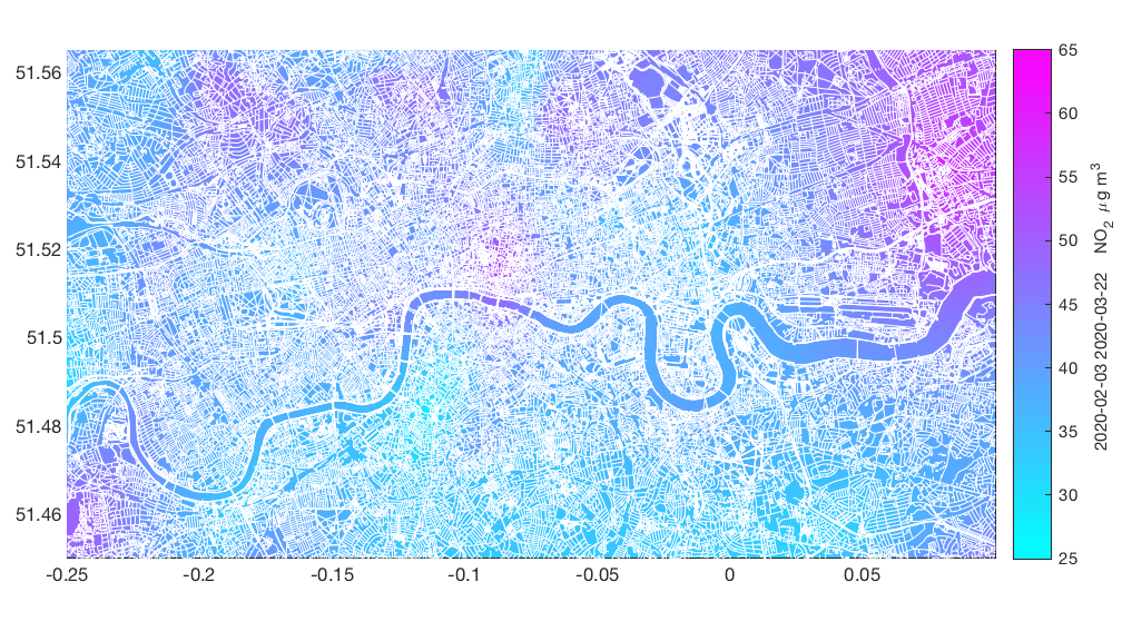
MAY 2020 | FEATURED IN THE ARCHITECTURAL ASSOCIATION EARTH DAY EXHIBITION - PROJECT BLUE SKY THINKING
Blue Sky Thinking displays the pre and post COVID-19 air contaminant concentration in the city of London. As reported by the World Economic Forum the built environment plays a critical role in planetary health and citizen wellbeing. This interdependency has become very apparent during the COVID-19 pandemic. Now, more than ever, we have a profound opportunity to communicate to the entire world the importance of the design of cities in health. There is no choice to be made between planetary health and human health, the two are inextricable. The data collected by the Breathe London air quality network has been used to illustrate the decrease in the NO2 air contaminant concentration after the lockdown imposed
on March 23rd.
OCTOBER 2019 | 2020 COALITION FOR ACADEMIC SCIENTIFIC COMPUTATION (CASC) DATA REPRESENTATION AWARDEE
Team: Maider Llaguno-Munitxa, Elie Bou-Zeid, William Guthe, Eliot Feibush -
Princeton Uiniversity.
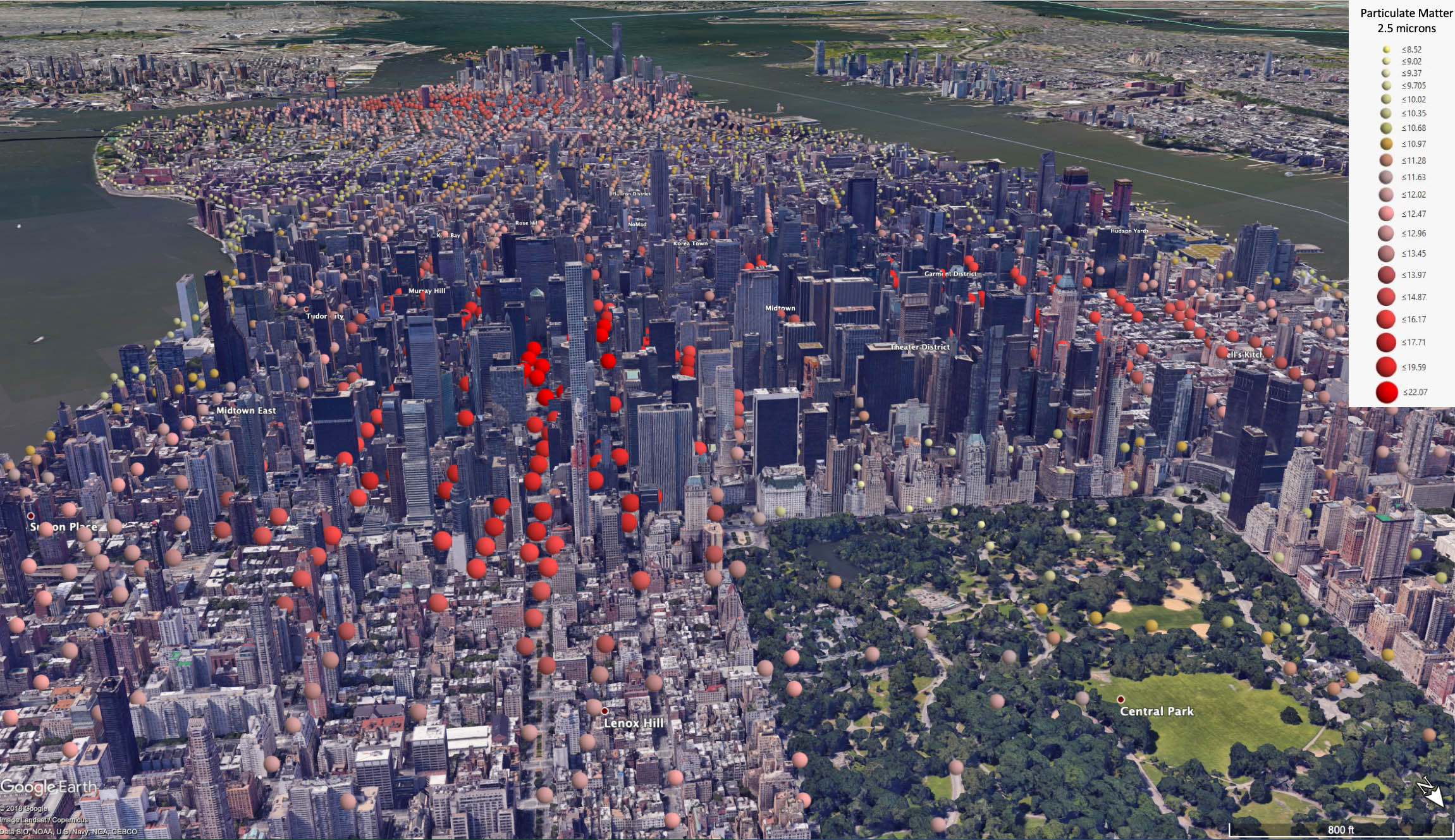
How’s the Air on Your Block?
In general, the air is more polluted in cities than in the countryside. But how does it vary block by block? With this image, Princeton University researcher Maider Llaguno-Munitxa and professor Elie Bou-Zeid in collaboration with William Guthe and Eliot Feibush represent the hyper-local variation of the concentration of 2.5 micron particulate matter - the type of air pollution considered most harmful to human health – in New York City.
The visualization uses data collected from a network of stationary and mobile air quality sensors that can perform street-by-street air quality surveys, and displays them spatially utilizing the Google Earth map of Manhattan. Pollution is highest around the most densely developed areas but as you stroll over to Central Park, the concentration plummets, underscoring how emissions from traffic and buildings influence the air we breathe. Making the invisible threat of air pollution visible in this way can help researchers and the public better understand pollution sources and how to control them.
AUGUST 2019 | LAND DER IDEEN_ BEYOND BAUHAUS PROTOTYPING THE FUTURE AWARDEE
The international competition "beyond bauhaus - prototyping the future", sought ground-breaking design ideas and concepts that address a socially relevant topic and provide creative answers to the pressing questions of our time.
Project: Our project, Cityreader described the use of Mobile environmental sensing stations to record urban environmental data in real-time and enabling novel visualization technologies
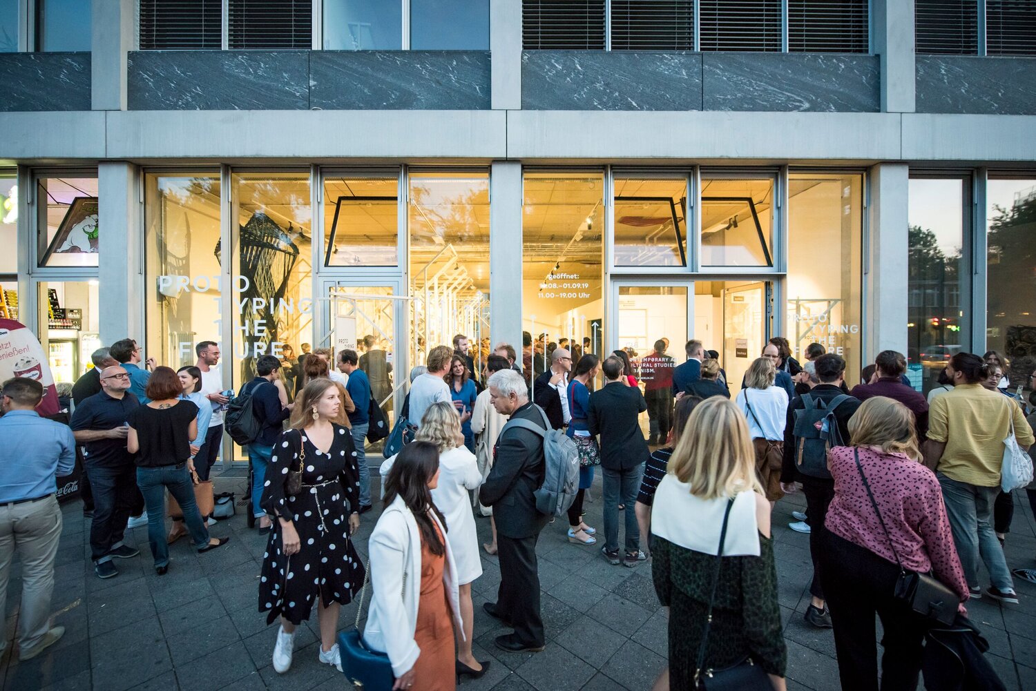
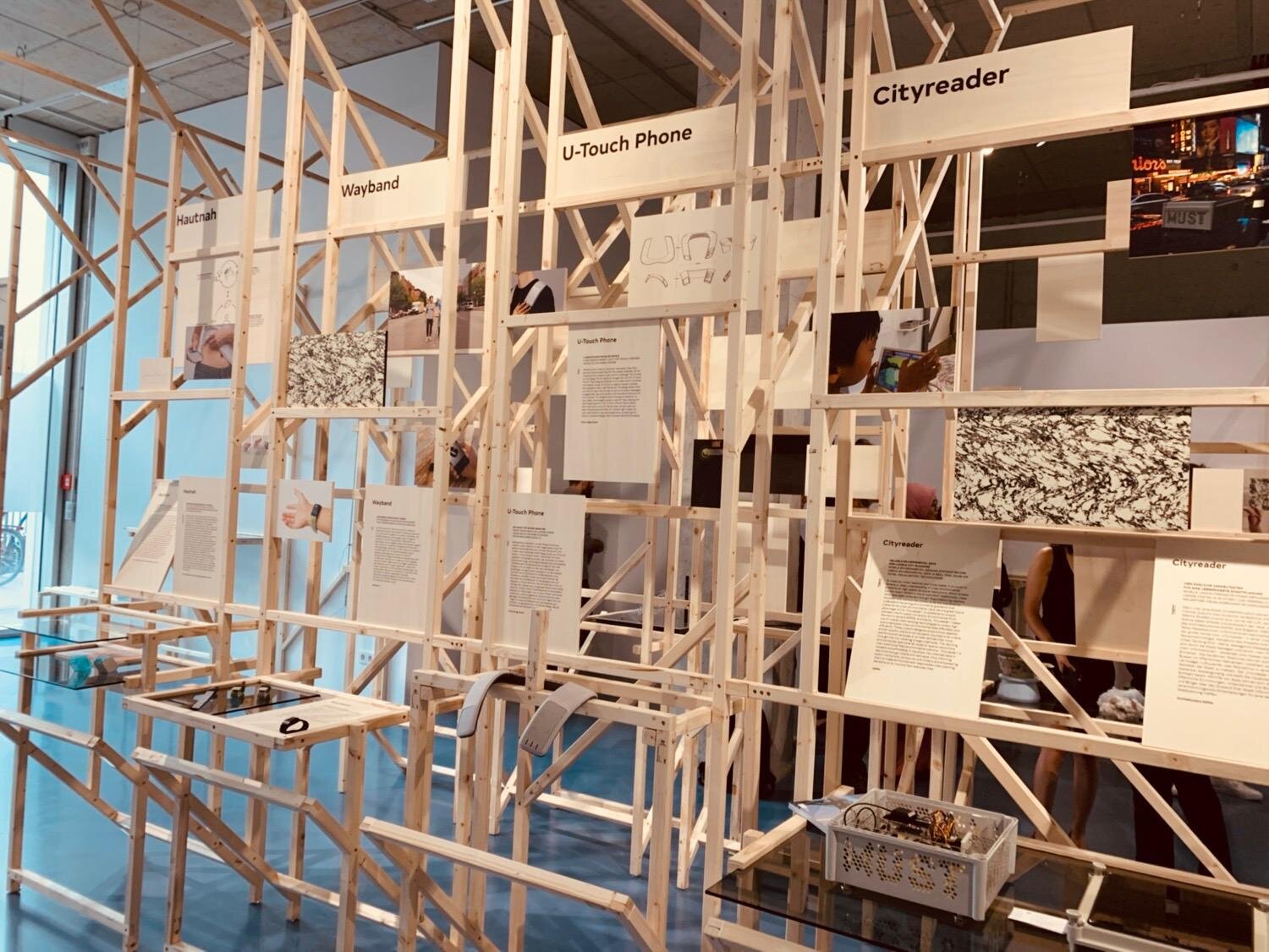
photo credit: Bernd Brundert/Deutschland – Land der Ideen
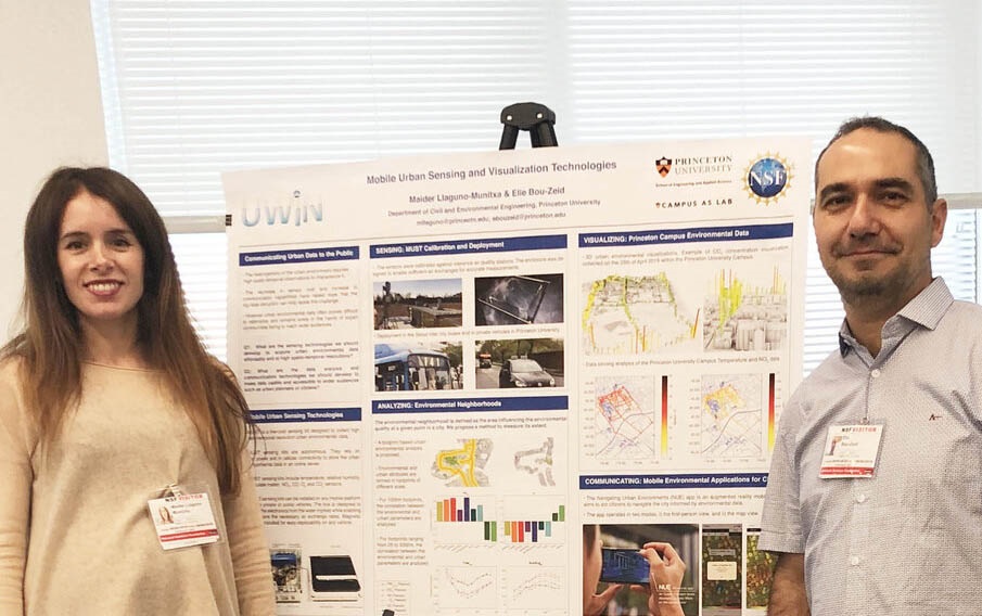
JUNE 2019 | NATIONAL SCIENCE FOUNDATION SRN AWARDEES ANNUAL MEETING
Project: Mobile Urban Sensing and Visualization Technologies.
Presentation as part of the Urban Water Innovation Network UWIN (The network is a consortium of multiple academic institutions and key water industry partners with activities currently in six regions across the U.S)
OCTOBER 2018 | NEW YORK AIA _ COLLAPSE : CLIMATE, CITIES & CULTURE CONFERENCE
Organized by: Peder Anker, Louise Harpman, Mitchell Joachim.
Panelists: Mark Foster Gage, Maider Llaguno-Munitxa, Ioanna Theocharopoulou, Julia Watson, Alejandro Zaera-Polo.

JUNE 2018 | NEW YORK UNIVERSITY GALLATIN _ COLLAPSE : CLIMATE, CITIES & CULTURE EXHIBITION
Global Design NYU (GDNYU) formed a traveling international exhibition between New York and Berlin open to the public that focuses on the design community’s response to environmental extremes. The exhibition uses architectural models, design prototypes, drawings, and videos to propose future scenarios to improve the health and well-being for our fragile planet and all of its occupants.
Project: Our piece included a marker based visualization of the air quality data and the display of the MUST sensing kit.
SEPTEMBER 2017 | SEOUL ARCHITECTURE AND URBANISM BIENNALE EXHIBITION
Project: SEOUL ON AIR. The piece explored 3-dimensional immersive environmental visualization techniques that enabled a user-friendly interactive analysis of the urban air quality data. The research focused on the implementation of low-cost mobile urban sensing technologies and immersive environmental data exploration mechanisms with the ambition of enabling citizens to reframe their role in the politics of urban air quality.
UCLouvain Current Research
Maider Llaguno-Munitxa is Assistant Professor at the Faculty of Architecture, Architectural Engineering and Urban Planning (LOCI), and Louvain Lanscape Architecture and Built Environment (LAB) Institute at UCLouvain. Maider is the leader of the urban science, climate and health team with the Architecture et Climat group at LAB UCLouvain. The following are some examples of ongoing research projects that are being developed in her team.
Click here to visit the Architecture et Climat group website.
Green Brussels | Current Work
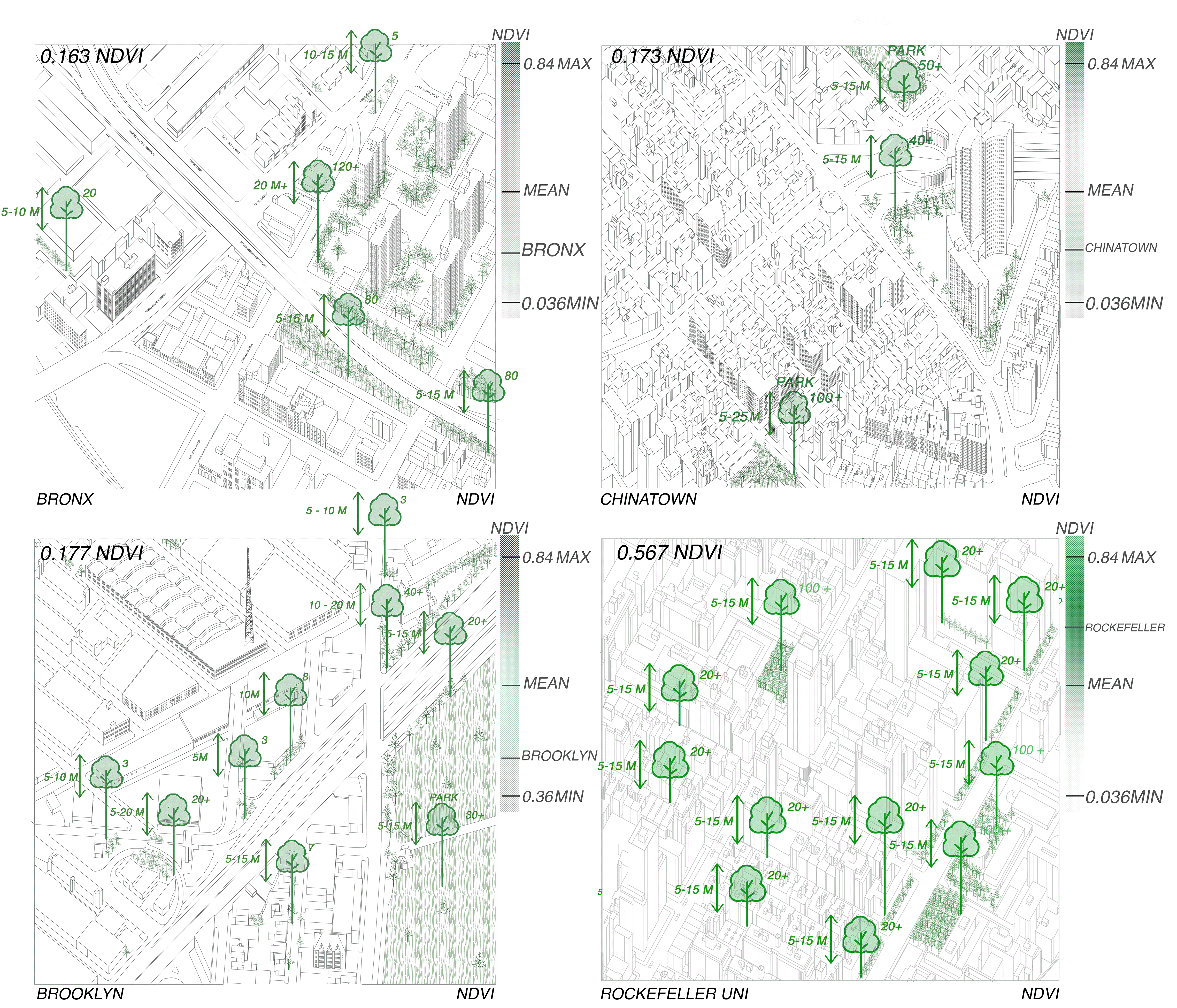
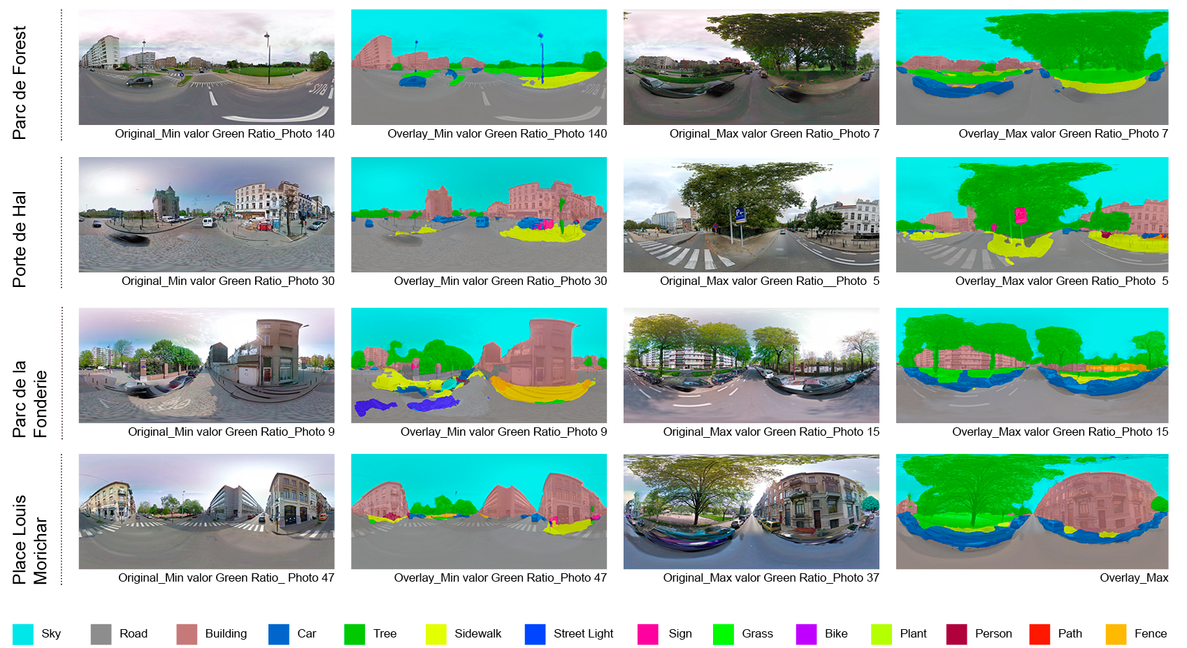
This research proposes a novel methodology to quantify Urban Green Infrastructure (UGI), and its visual accessibility, combining remote sensing, image processing, and LiDAR scanning technologies. The Brussels Capital Region (BCR) is used as case study. Through an aerial survey, the normalized difference vegetation index is computed. Through a pedestrian-level survey and using 360° Google Street View imagery and semantic classification, novel UGI indicators to document the UGI types, their ratios, and their position relative to the camera are studied. Finally, through the use of aerial and pedestrian level LiDAR scanning, a detailed 3D characterization of the urban forest is developed. PI Llaguno-Munitxa, Maider.
Urban Design & Citizen Health | Current Work
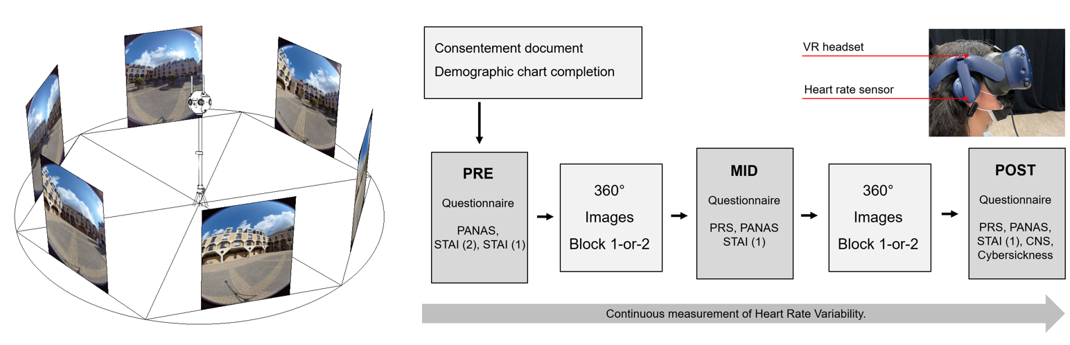
One third of adults report suffering from high stress levels, and these numbers are escalating, driven by global trends towards urbanization and socioeconomic and environmental pressures such as those induced by the COVID-19 pandemic. Mental health conditions such as high stress levels, peak in cities as opposed to rural environments. Today more than 50 percent of the global population is living in cities, and by 2050, it is expected to increase to 70 percent, and thus urban stress is one of today’s most critical health challenges that urban stakeholders need to urgently address. This research proposes a novel methodology to evaluate the role urban design decisions play in our mental health using virtual reality, eye-tracking technologies, biometric sensing, and participant questionnaires. Through these combined methods, the psychological and physiological stress level reduction capacity of distinct urban design strategies is evaluated. PIs UCLouvain Llaguno-Munitxa, Maider; Edwards, Martin.
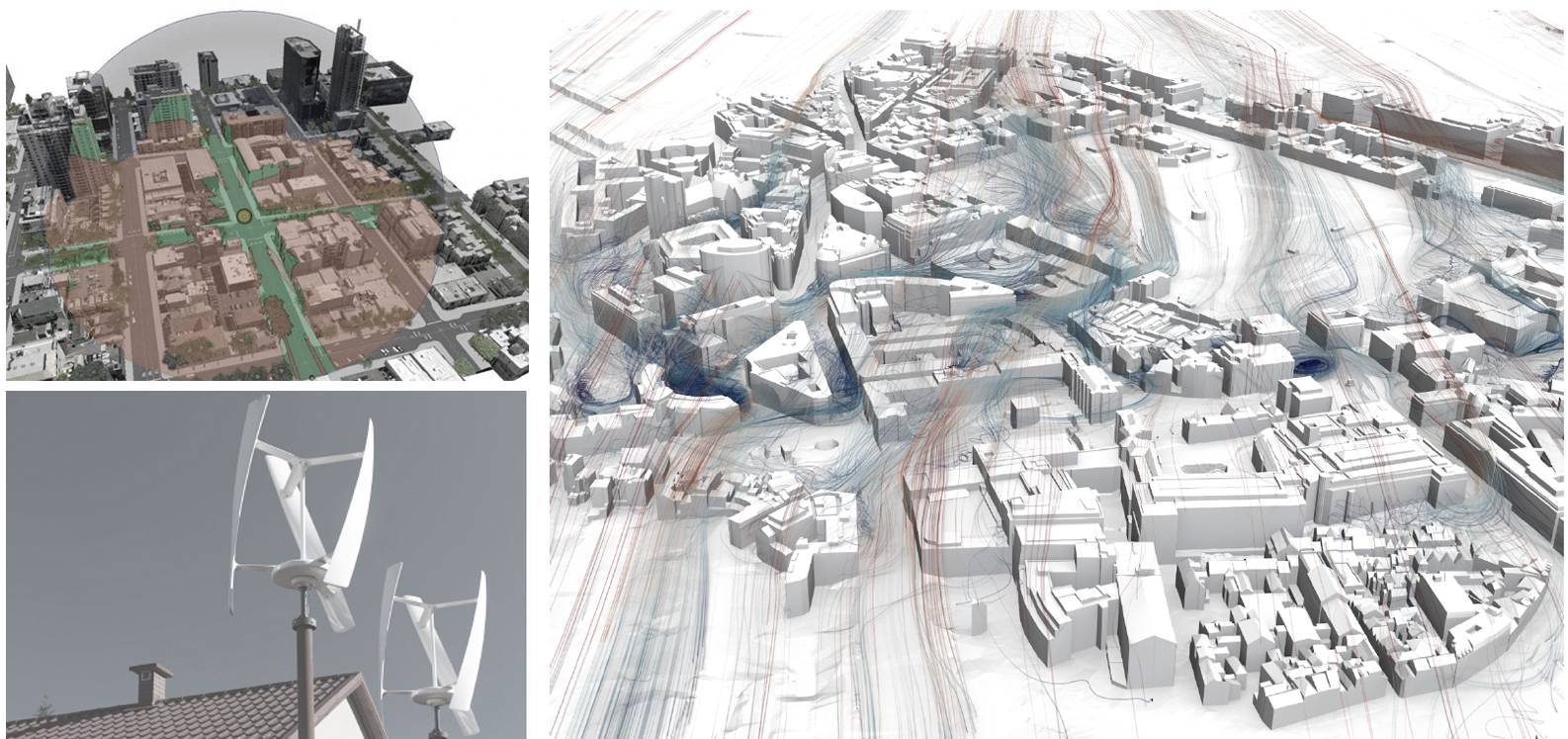
Wind Energy Brussels (WEB) | Current Work
This project aims to develop a comprehensive approach to report the potential energy production and
life cycle assessment of urban wind energy harvesting, to inform sustainable urban policy making
processes. Our analysis will identify the locations in an urban area that are most suitable for wind
energy harvesting by performing extensive and accurate wind simulations of two municipalities of the
Brussels Capital Region using Computational Fluid Dynamics (CFD). Simulations will be based on
meteorological data from the last 30 years, and will make use of detailed 3D models of buildings and
terrain, to predict the annual energy production associated with a particular turbine. The visual impact
of urban wind turbines will also be quantified. The impact of the extensive adoption of urban wind
energy harvesting will be assessed using a life cycle assessment (LCA) to ensure that the deployment
of wind turbines results in a net environmental benefit and to understand environmental hot spots in
the production, use and end-of-life.
Team: PIs UCLouvain - Prof Altomonte, Sergio; Llaguno-Munitxa, Maider; Stephan, Andre | PI BuildWind Enterprise Gambale, Alessandro.
Funding Agency: Innoviris - Brussels Capital Region.
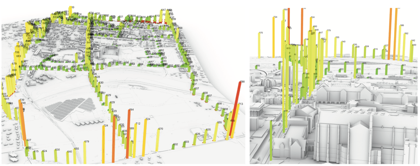
City Information Modeling | Current Work
This research focuses on the development of an interactive planning tool to assess the environmental impacts of changes in block and parcel-level characteristics, such as FAR (Floor Area Ratio), UGI (Urban Green Index) ratios, and facade consolidation, among others. A CIM (City Information Modeling) model was created, incorporating both underground and above-ground geospatial layers, enabling a comprehensive assessment of environmental characteristics at the urban block and parcel levels. The tool's interface allows users to explore the data by interacting with elements in the 3D model, which can be navigated in real-time. Alternatively, users can access the data through a dashboard, providing detailed parcel-level information for more in-depth analysis.
Below an image of the online interface of the 3DCITis research project is shown.
Team: PI UCLouvain - Prof Cavalieri; Digital CIM and interface design WP Lead; M.Llaguno-Munitxa.
Funding Agency: Innoviris - Brussels Capital Region.
HESTIA - HEat STress Inquiry & Alleviation | Current Work
This study aims to provide a comprehensive assessment of environmental exposures by integrating dynamic population data with environmental stressor analyses. Specifically, we propose a methodology that captures day-to-night population dynamics, and conduct a multi-exposure analysis by examining both positive and negative environmental factors simultaneously. By leveraging advanced modeling tools and diverse environmental datasets, our research seeks to offer a holistic understanding of urban environmental stressors, ultimately contributing to more effective urban planning and policymaking.
Team: PI UCLouvain - Prof Llaguno-Munitxa. PI EPFL - Gabriele Manoli.
Below an image produced by PhDc - Yen-Shuo Huang.

Postdoctoral Research
From 2017 until 2020 Maider Llaguno-Munitxa was a postdoctoral research associate at the Princeton University Department of Civil and Environmental Engineering. During her postdoctoral work Maider Llaguno-Munitxa focused on the development of data processing and analysis strategies for the visualization, understanding and incorporation of urban environmental data in the urban design processes.
Digitalization of information and ubiquitous sensing in cities are enabling the collection of data at unprecedentedly high temporal and spatial resolutions. However, these data are most often not accessible or are too cumbersome for designers to engage with. This is particularly the case for urban environmental and health data. Thus, in most cases, urban environmental data fail to inform urban design and architectural design practices. The following include a set of experiments developed along Maider Llaguno-Munitxa's postdoctoral work which aimed at introducing urban environmental data in the design process to aim for the improvement of urban health and well-being.
For more information on the most recent postresearch see: CITYREADER Website
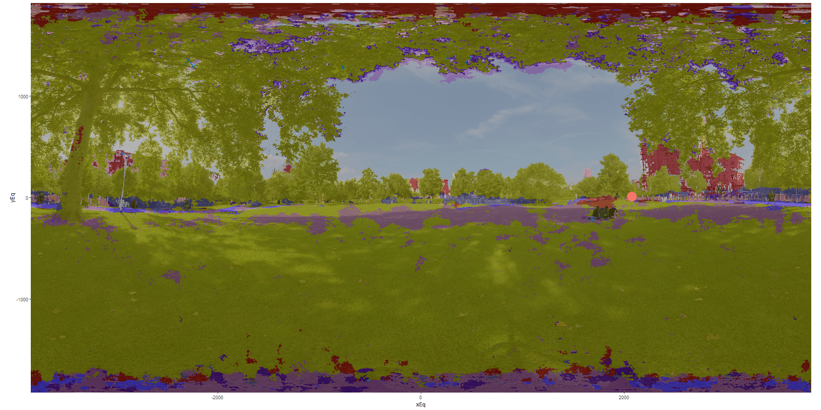
Environmental Neighborhoods | Postdoctoral Work
The aim of this research is to understand the effect the local physical attributes of neighborhoods (the architecture and street design) affect the local environmental quality. The new concept of environmental neighborhood is defined as the surrounding area influencing the environmental quality at a given point in a city. The researh proposes a novel methodology to measure its spatial extent. We compute the spatial correlation of air quality and urban parameters from high spatial resolution datasets for New York City. The scale at which these correlations peak indicates the extent of the neighboring area that influences pollutant concentrations deviations from the city-wide average. The results indicate that the scale of these environmental neighborhoods ranges from ~1000 m (for attributes such as road area or building footmark) down to ~200 m (for building use or green area). More broadly, the findings indicate that, in a wide range of environmental and ecological applications where surface heterogeneity is a primary driver, the scale of analysis is not an external parameter to be chosen, but rather an internal parameter dictated by the problem physics.
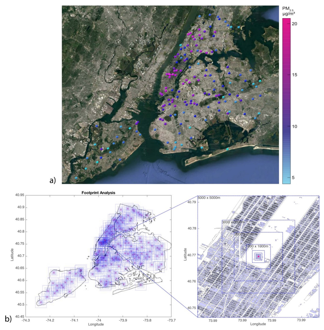
NYCCAS station locations colored based on the mean PM2.5 concentration recorded between 2008 and 2016. (b)
Footprint Analysis methodology with footprints for all NYCCAS air
quality station locations.
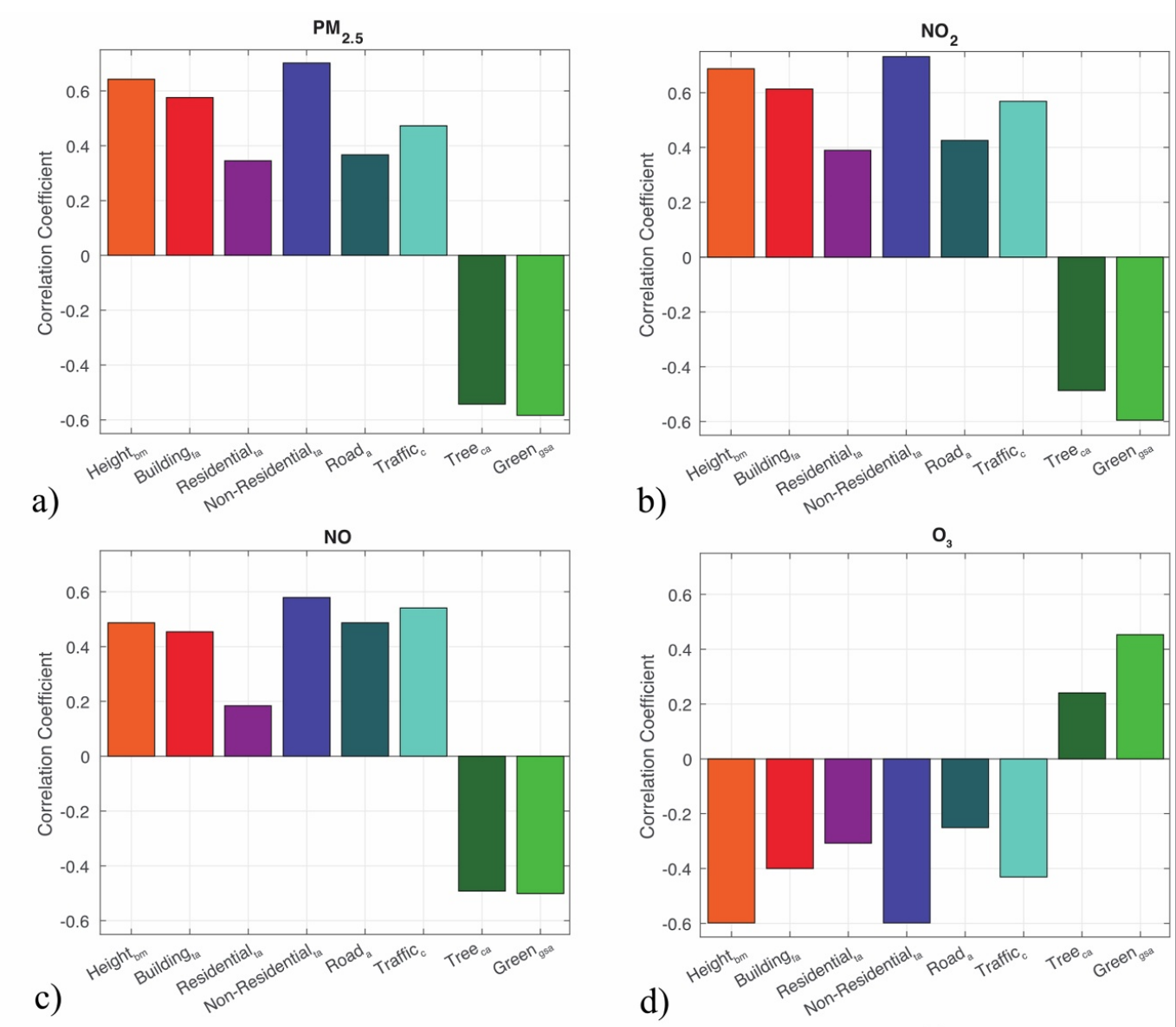
Urban parameters and NYCCAS mean contaminant concentration correlations averaged across footprint scales from 25
to 1000 m.
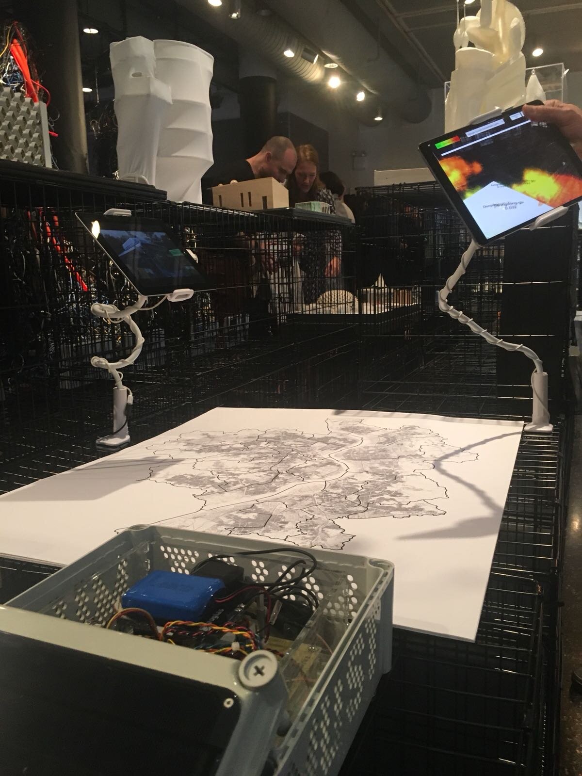
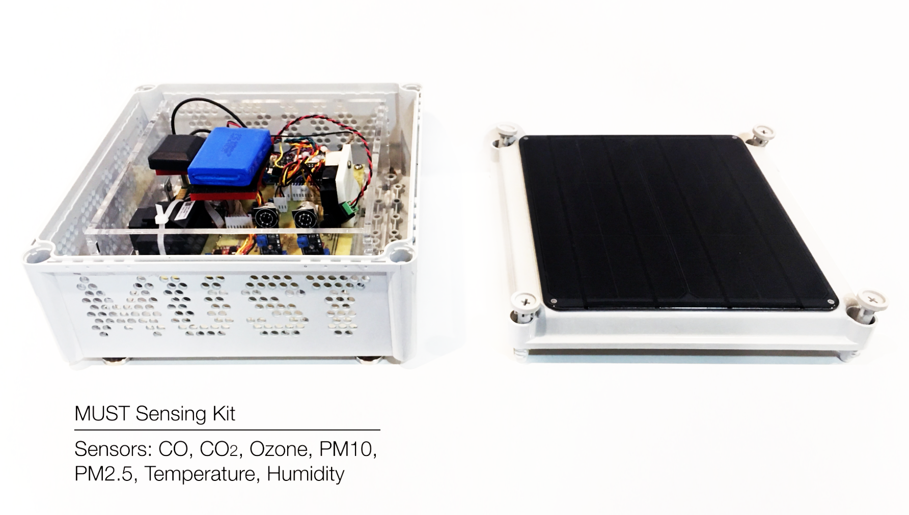
MUST | Mobile Urban Sensing Technologies. Postdoctoral Work
The aim of this project is to collect and visualize high spatio-temporal resolution urban air quality data. Air quality data are generally collected through fixed urban weather stations, which generally offer a low spatial resolution coverage. A mobile sensing methodology is proposed to acquire data at higher spatial resolutions. This method enables the acquisition of gradients of the contaminant concentrations across the city, contributing to a better understanding of air quality dynamics to inform local environmental urban planning strategies. An autonomous sensing kit named Mobile Urban Sensing Technologies (MUST) was pursposedly designed to be deployable over any mobile platform such as private or public vehicles. Six MUST sensing kits were installed in the Seoul city inter city bus network. Data was collected for one month and a half (from August 29 2017 until October 6th), and it was made available in real-time in the website: must.princeton.edu in the form of 2d graphs and maps.
Princeton University Campus Environmental Data Visualization
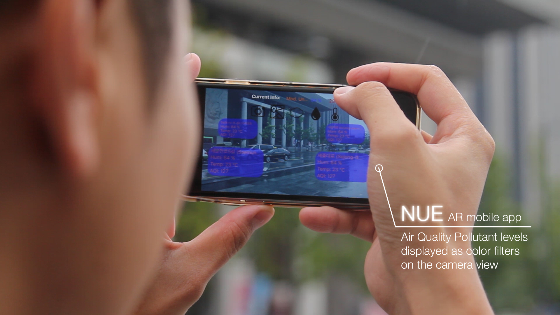
NUE | Navigating Urban Environments. Postdoctoral Work
Navigating Urban Environments (NUE), is an Augmented Reality (AR) mobile app that displays on-site high spatiotemporal air
quality data. NUE is a user-centered app that enables a direct engagement with the surrounding environment. Its information
visualization corresponds to real-time data acquired from urban Geographic lnformation Systems (GIS), weather station networks and
MUST sensing networks. In the NUE app, two AR environmental visualization modes are enabled, the first-person view,
and the map view. In the first-person view, locational services of the user's mobile device are accessed, and by referencing
the mobile GIS platform, geotagged environmental data is overlaid on the camera view as graphic filters. The app
also enables a map view of the environmental data through accessing geolocation and uses Google Map API services
over which environmental gradients are overlaid.
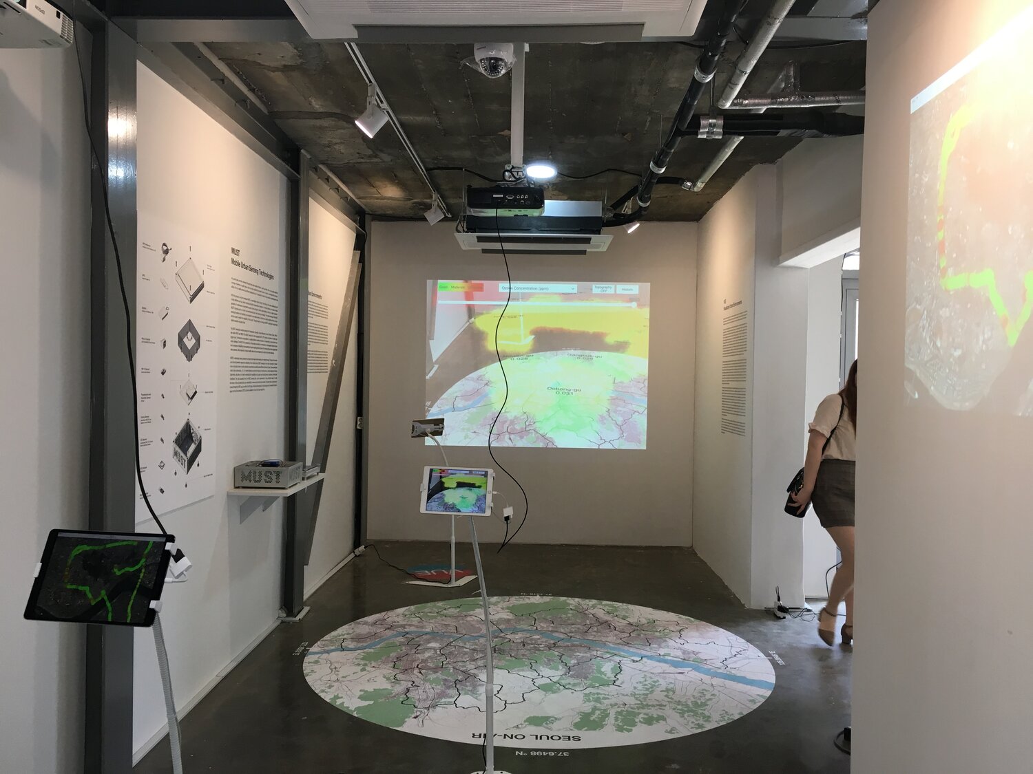
VUE | Virtual Urban Environments. Postdoctoral Work
Visualizing Urban Environments (VUE), is a marker based augmented reality mobile app that aims to compliment the currently
available city scale environmental data. The VUE app enables a spatiotemporal visualization of all Seoul districts' air
quality. VUE is an immersive experience that makes the citizens aware of their immediate microclimate while highlighting
the interaction between environmental and urban parameters. The VUE app can be displayed in any space where the
designated Seoul markers are visible. These markers are composed of various GIS and Remate Sensing layers of Seoul
and trigger the app to visualize air quality data over it. Historical air quality data from 1986 to 2016 can be viewed through
interacting with a slider and dropdown menu. For 2016, an hourly visualization is made available to understand the seasonal
variability as well as the diurnal variability of the air quality data. Data for PM1O, PM2.5, 03, S02, N02, and CO is
made available. Furthermore, the app enables real time data to be visualized over the city map. The setup aims to encourage
the viewer to make correlation between the historical and real-time air quality data, while viewing the complexity
of urban and geographic layers.
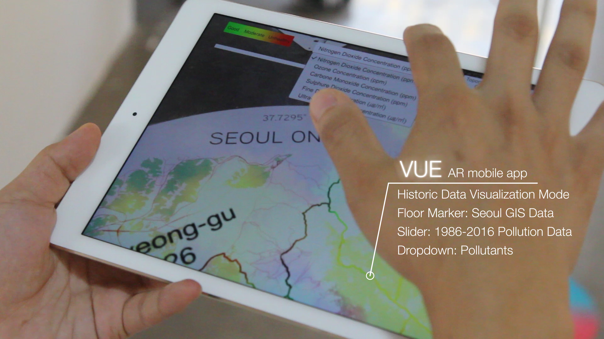
VUE app interaction at the SEOUL 2017 Architecture and Urbanism Biennale
PhD Research
In this dissertation, design-analysis workflows to facilitate the introduction of airflow analysis in the architectural design process were presented. In the following sections, some examples developed as part of the PhD thesis are included.
Currently, despite the growing awareness regarding the influence of architectural design parameters on the neighbouring urban microclimates and air quality, as well as the role of airflow in structural dynamics, architectural designs generally fail to include airflow performance considerations within the design criteria. One of the main barriers for this lack of integration is to be attributed to the available analysis tools for the study of urban microclimates and airflow phenomena. These analysis platforms rely on computationally highly demanding numerical simulations and technically onerous wind tunnel and field experiments, which involve high economic expenses as well as specialized technical expertise for their management. Therefore, the available analysis platforms for the study of airflow prove unaffordable for most architectural design practices.
The relevance of this dissertation centres on the contribution to reduce the gap between architectural design and the available airflow analysis methodologies. The focus has been to look for potential work-flows where architectural design and airflow analysis platforms can establish productive dialogues. With this ambition, the research has looked into complementary work-flows to contemporary numerical and experimental airflow analysis platforms. Following the 3 main stages of the design process, that is, the conceptual stage, the design development stage, and the detail design stage, strategies to incorporate airflow analysis along the different stages of the architectural design process have been sought.
1. Street Canyon Ventilation Studies. PhD work
The objective of the following study was to investigate the effect of street canyon building geometry on the mean wind flow and turbulence in a street canyon
within an urban environment. Wind tunnel experiments and large eddy simulations have been conducted to test different geometries in configurations consisting of seven building arrays, (aligned in
the spanwise direction) to simulate urban roughness elements.
The models have been tested in a closed loop wind tunnel located in Princeton University’s Instructional Fluid Dynamics Laboratory. The tunnel
is a modified version of a wind tunnel model 407-A manufactured by Engineering Laboratory Design, Inc. The test section of the tunnel is 0.61 m
(height) × 0.91 m (width) × 2.44m (length).
The flow velocity measurements were conducted using a thermal anemometry system for quantitative measurements as well as throgh smoke visualization.
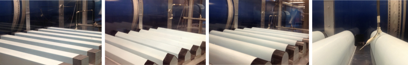
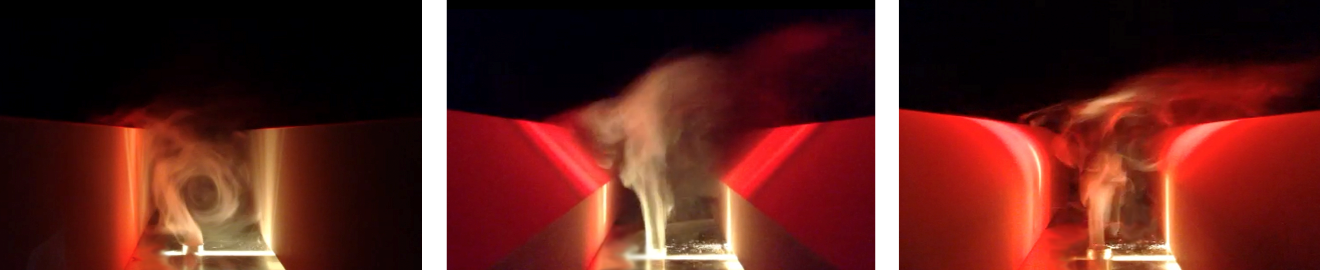
Princeton University MAE Fluid Mechanics lab. Wind tunnel 7 building array setup for three different building geometries.
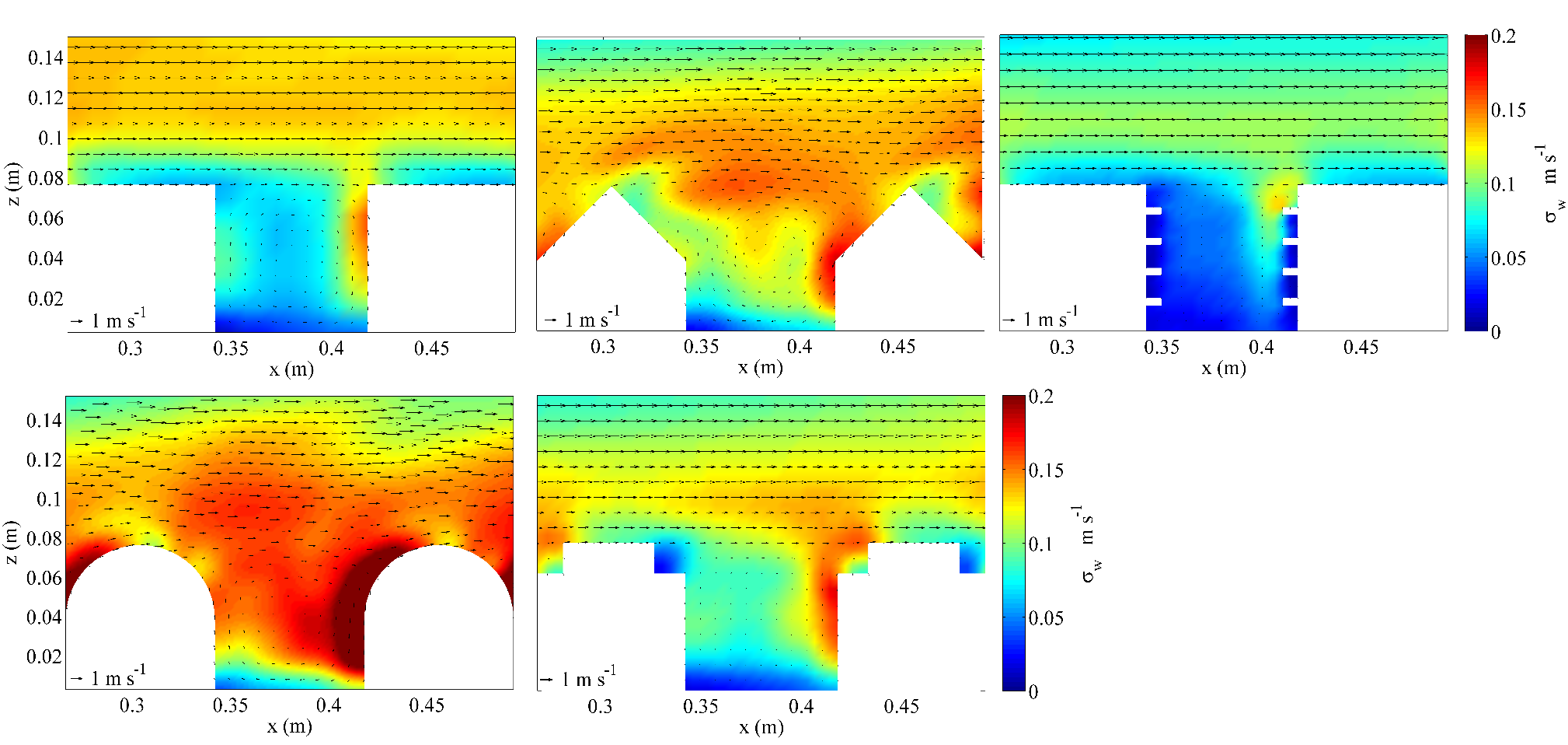
Large eddy simulation studies for 5 different street canyon geometries.
2. Interactive Wind Tunnel Design for Building Geometry and Urban Flow Exploration. PhD work
Usually CFD simulation platforms and WT experiments follow a linear i) model ii) measure iii) analyze cycle. This workflow complicates the interaction
between the designer and the experiment constraining the number of design tests to be performed and in most of the cases delaying the
airflow studies to the end of the design process. The following research describes an alternative method. A robotic arm has been coupled to a low speed and turbulence open circuit wind tunnel
to enable the wind tunnel to be used in three different setups: Modelling setup, Sensing setup, Flow visualization setup. With the aid of a robotic arm, the modelling and
sensing phases are collapsed to enable a real time design feedback informed by airflow analysis. By coupling a smoke emitter to the robotic arm, the flow visualization setup is also enabled for a more intuitve undersanding of the air flow dynamics around the buildings under study.
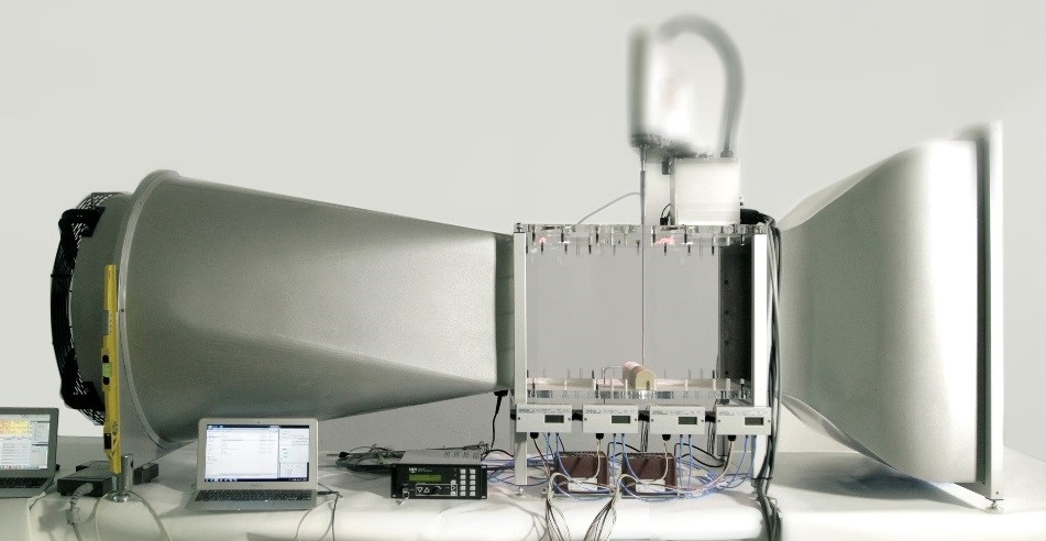
Experimental wind tunnel setup with robotic arm mounted over test section.
Robot working setups: Modelling setup, Sensing setup, Flow visualization setup.
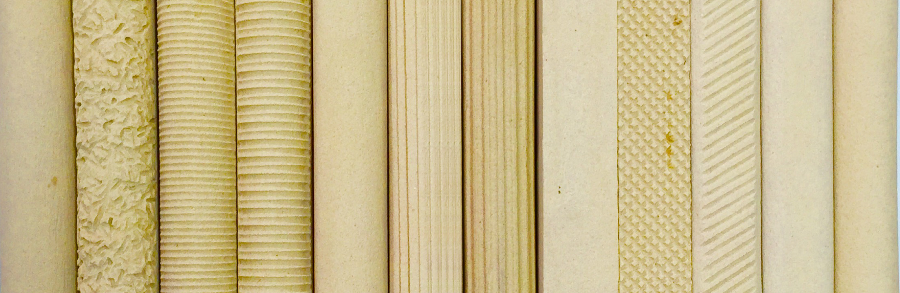
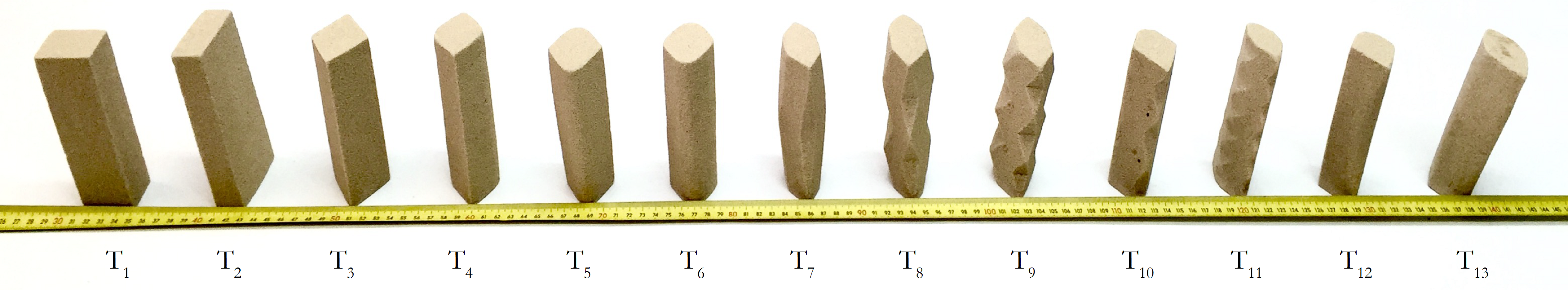
2.1 Study of building surface texture on flow adherence.
This case study developed in the described wind tunnel setup, looks into the influence of building surface textures on the neighboring airflow dynamics. From form to
texture, the effect of building surface detailing on airflow separation in the interface of the Urban Canopy Layer and the free atmosphere is studied.
The study aims to detect the sensitivity of texture variations on the flow separation and flow reattachment. These are important parameters to be considered
given their role on street ventilation potential. The angle of attack has been constrained to 90º, representing canyons that are perpendicular to the
mean wind.
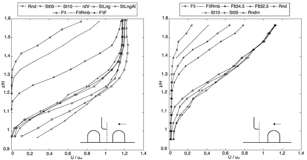
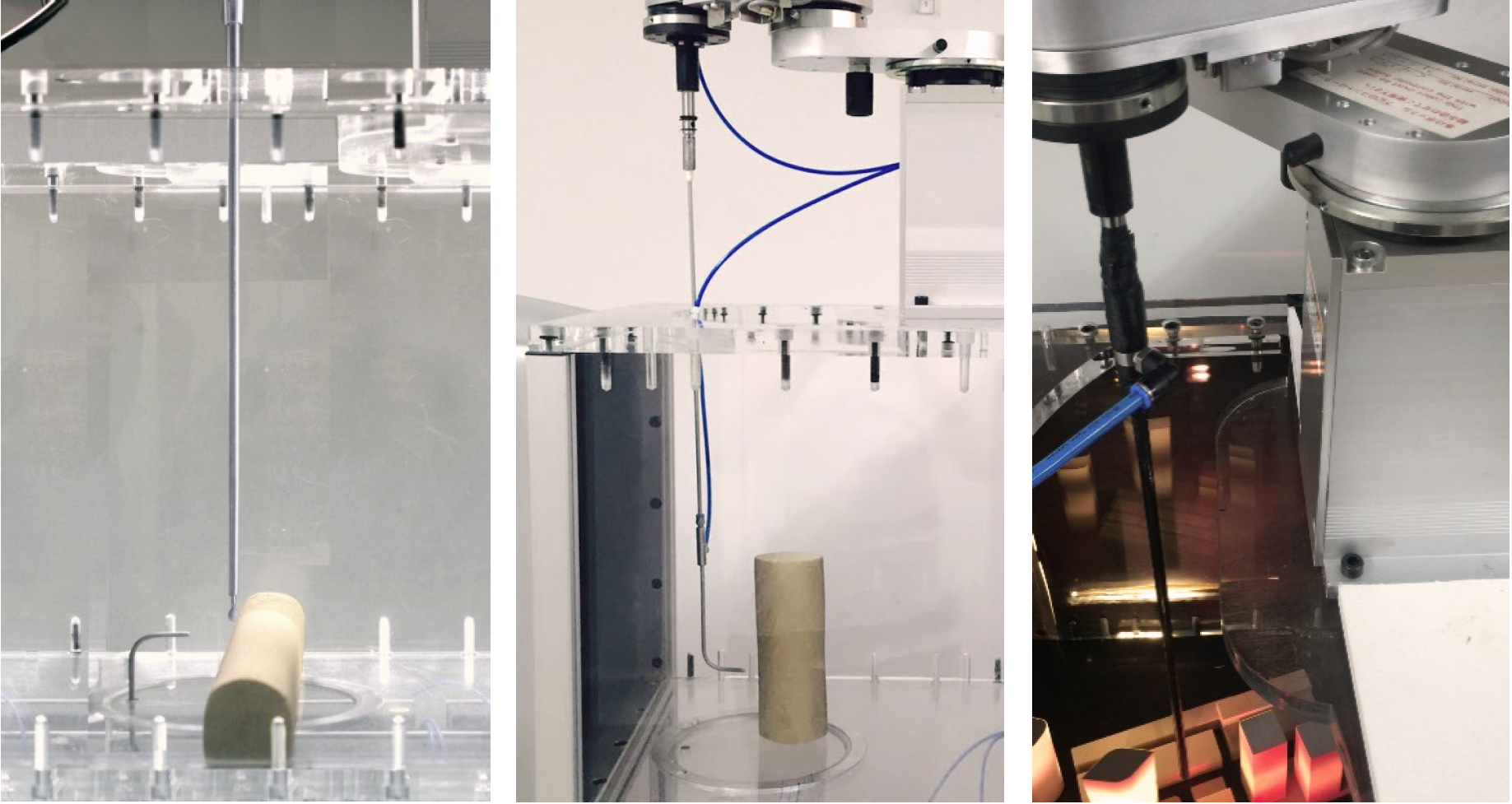
2.2 Robot-aided interactive flow visualization for wind tunnels.
This case study developed in the described wind tunnel setup, looks into the influence of tower geometries in the neighboring air flow dynamics. Quantitative and qualitative studies were developed. The results below show some of the visualizaiton obtained through the flow visualization setup. By mounting a smoke emitter to the robotic arm, this setup enables the smoke emitter to be easily repositioned, reducing the amount of smoke to
be emitted, and enabling a qualitative visualization to understand the flow behaviour when interacting with the different building geometries. Two geometries are displayed, a rectangular and a dyamond shaped floorplan tower. The smoke visualization reveals that the wind downdraft and
wake behind the tower are very sensitive to the building goemetry. Corner geometries also appear to strongly affect flow separation.
Experimental wind tunnel setup with robotic arm. Tower geometry studies.
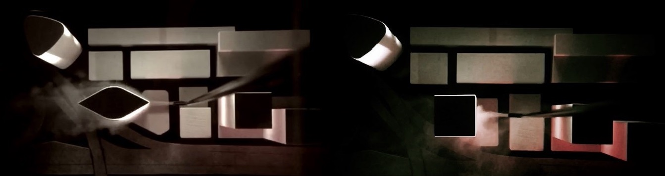
Experimental wind tunnel setup with robotic arm. Tower geometry studies.
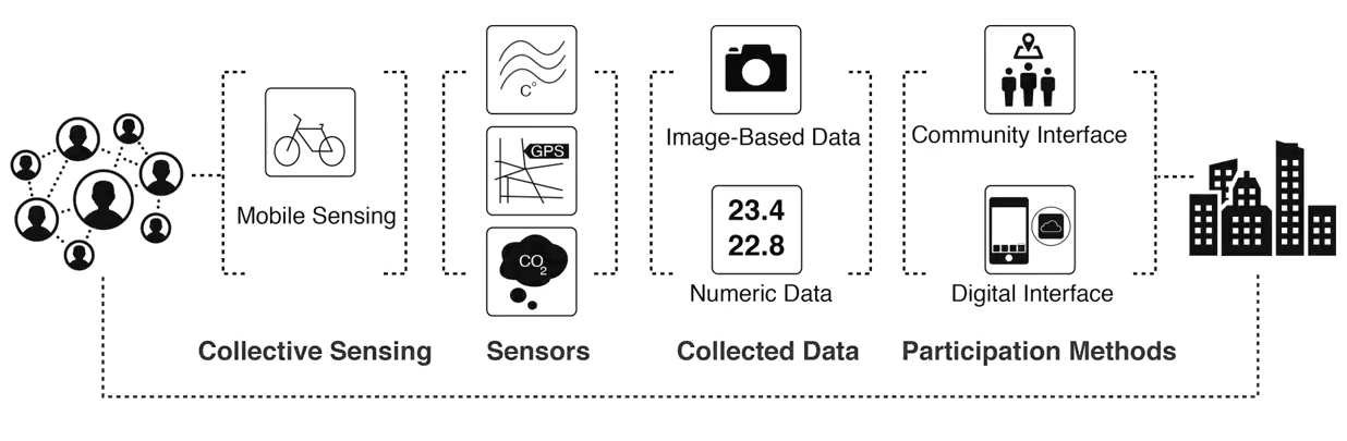
3. Urban Sensing. PhD work
Our understanding of the relationship between city morphology, materiality and urban microclimate has been limited due to the lack of availability
of urban microclimate data. In order to better understand the influence of building geometries, trees, or topographical variations play in urban
microclimates, it is necessary to utilize measuring techniques that gather higher spatial resolution urban environmental data than that of weather
stations or static sensor networks. With this purpose, this research proposes to utilize accessible low-cost technologies for environmental sensing
coupled with dynamic devices. A custom sensor kit to record temperature, humidity and CO2 concentrations, has been mounted to a bike for
pedestrian level microclimate sensing. The same sensing kit has been attached to an Unmanned Aerial Vehicle (UAV) for the vertical gradient profile
measurements. Image, video processing techniques and GIS data have been utilized to visualize the recorded measurements and to parameterize
the urban properties (green areas, impervious surfaces and building masses) around the acquisition trajectories. The correlation of the acquired
measurements and the urban parameters, show that maximum CO2 concentrations mainly peak in road intersections. Building masses and greenery
also appear to affect the distribution of pollutant concentrations both in the pedestrian level and in the vertical profiles. While dynamic sensing
attains sufficient spatial resolution, it does not provide high temporal resolution. With the aim to improve data accuracy through data redundancy,
the proposed DIY sensing kit utilizes readily available sensors and operates on open-source platforms to encourage the engagement of larger audiences.
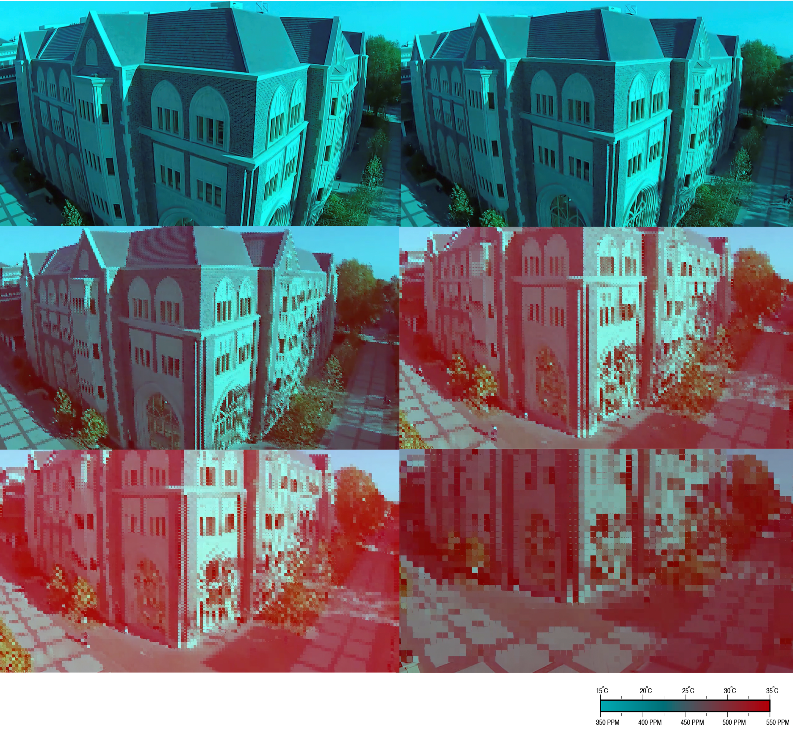
Urban Sensing. UAV based environmental mapping
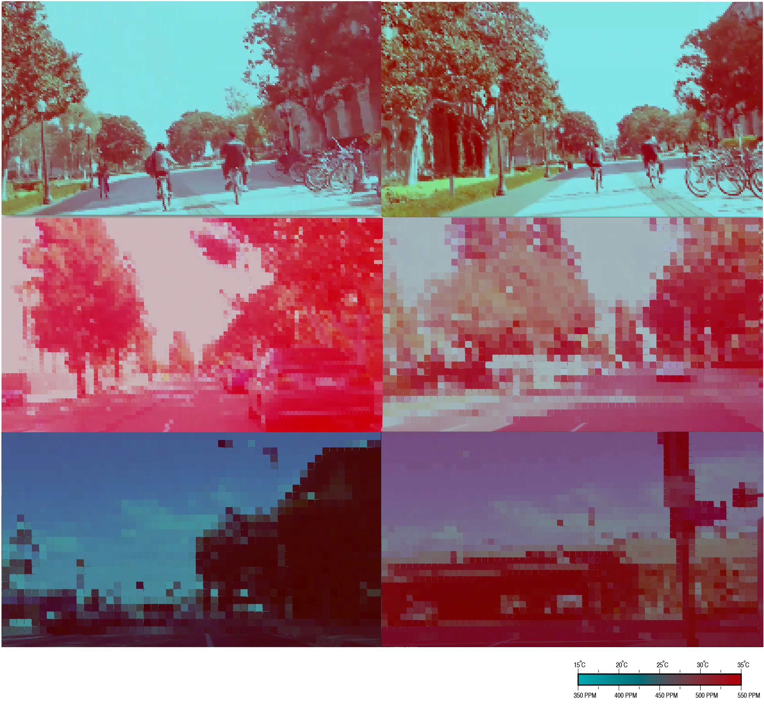
Urban Sensing. Bike based environmental mapping
Urban Sensing. Bike based environmental mapping
Los Angeles CitySense project submitted in 2016
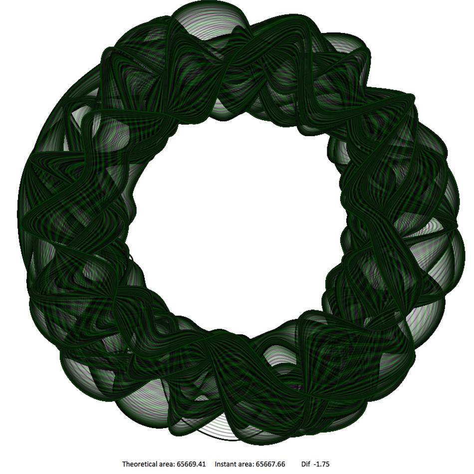
Code Sketches
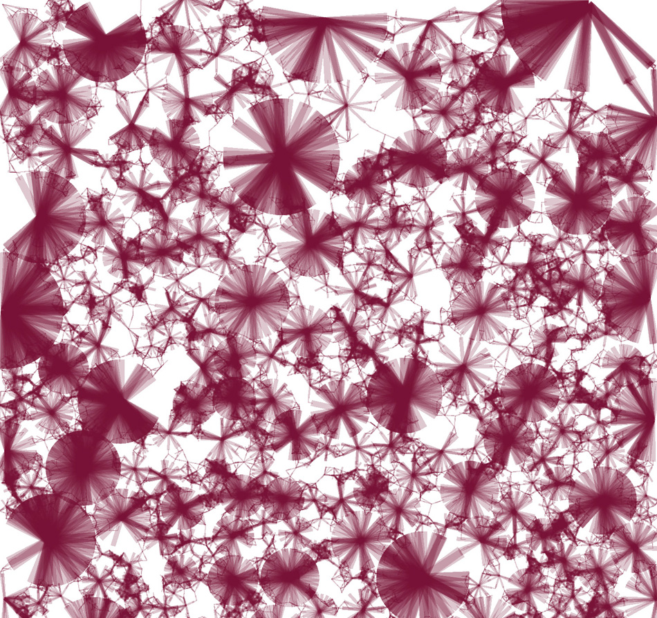
The following are a set of coding sketches developed by Maider Llaguno-Munitxa to explore procedural aesthetic sensibilities through the development of processing applets. 2Dimentional and 3Dimentional growth and decay patterns were explored as synthetic studies of living structures.
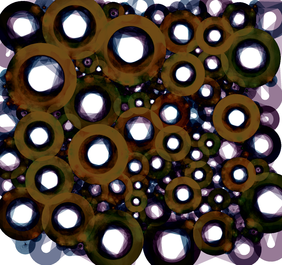
2d packing variations | Every time a circle hits another circle, a connection is created. Over time and iterations, a tree like structure is generated, the thickness of the line being proportional to the distance to the connection branch. Also, the opacity of the lines is related to the connectivity of the circle.
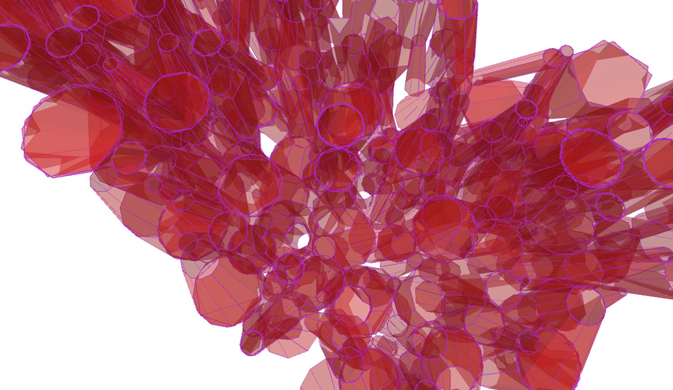
Aggregation and Crystals| Studies on packing and stacking; These experiments show component based basic 3 dimensional organizational structure studies. Attention is placed in the connection points between the components as these connections will determine the structural performance of the assemblages.
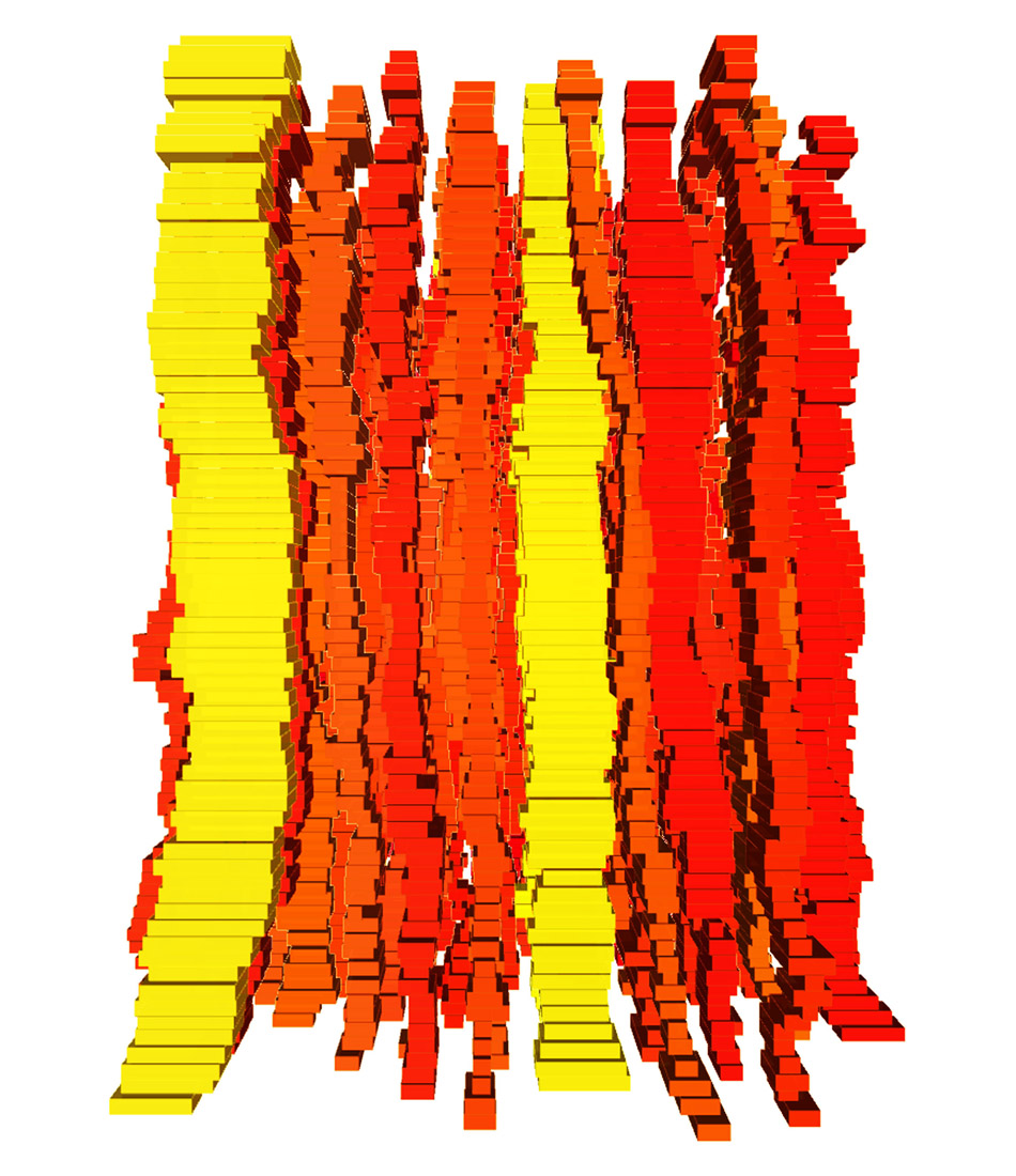
Paired Connections | These experiments show patterns of paired up units; The test includes a vertically growing population that measures the distances to the neighbours. The units are paired up when they accicentally touch, and they search for an empty slot on their vertical axis. The process creates a spiralling organization of units. The geometry of these units is adjusted according to their neighbour’s proximity, size, and location in Z.
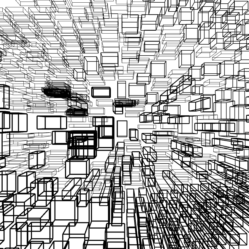
Block Stacking | The system generates a stacking organization where each element knows where its surrounding = level volumes are. However it is not conscious about the information in z. The objects have a 2 dimensional view and each element is randomly loaded with a different criteria when negotiating the distance to the neighbours. The result, is a distorted stacking where the difference in behaviour between objects will be measured by reading the disagreement between levels
Block Relationships | Neighbour to neighbour relationships with no dialogue with the environment or any other external factors, some objects are thrown into a white room and their relationship constraints and tolerances generate a range of organizational outcomes.
Floorplate Area Calculations | Area calculation sensitive perimeter studies. The iterations show infinite possible variations within some given constraints such as, the rugosity tolerance, the amount of divisions or modules, and the minimum and maximum distance to the core. The sequence overlays the possible solutions within the given constrains.
Impact Responsive Surface – Soft Body | A landscape is sculpted by a distortive body. The bodies sculpting force is parameterized as well as its geometry and the amount of these. The surface is defined by its deformable points, levels, and rugosity tolerance. For these iterations the rugosity and tolerance values are kept within a 0 to 100 range.
Figure Rotation Variables| Environmentally sensitive skin studies; experiments on the dynamic factors that affect the physical constructions. The sun, the wind, the context, etc are the dynamic environmental conditions that the skin will respond to. The exercises isolate the dynamic influences in order to understand its geometric performance more clearly so that the skin is coded in a sensitive fashion to each specific external factor.
CV Highlights
2024-ongoing, Associate Professor LOCI-LAB UCLouvain.
2021-2024, Assistant Professor LOCI-LAB UCLouvain.
2020-Assistant Professor - CAMD Northeastern University.
2019-Research scholar at the Civil and Environmental Engineering Department at Princeton University.
2012-Ongoing Director of the architecture and urban design office AZPML based in London and New York City.
2017-2019 Postdoctoral researcher at the Civil and Environmental Engineering Department at Princeton University.
2018 Summer school workshop tutor, Tongji University CAU, Shanghai.
2013-2017 Adjunct Faculty GSAPP Columbia University.
2013-2016 Visiting Researcher at the Civil and Environmental Engineering Department at Princeton University.
2014 Dynamic Sensing. Acadia Hackaton workshop.
2012-2015 Architectural Association Bilbao San-Sebastian AA Visiting school director.
2011-2013 Instructor and Scientific Researcher at the chair of Structural Design ITA ETH Zurich.
2011 Berlage Institute summer school studio master.
2010 Studio instructor Summer and Fall 2010 Yale University.
2009 Technical Assistant for Hernan Diaz Alonso
Adv. Studio Columbia Univ & David Smiley Studio Barnard College of Art New York.
2007-2009 Architect at Foreign Office Architects in London.
Articles
Click here for google scholar.
Firas Gerges, Llaguno-Munitxa, Maider, Mark A.Zondlo & Elie Bou-Zeid (2024). Weather and the City: Machine Learning for Predicting and Attributing Fine Scale Air Quality to Meteorological and Urban Determinants. Weather and the City: Machine Learning for Predicting and Attributing Fine Scale Air Quality to Meteorological and Urban Determinants, 58, 6313-6325.
Llaguno-Munitxa, Maider, Agudo Sierra, Elena, Alejandro Burgueño-Díaz & Guillet, Alain (2023). Tree View Assessment: Survey of Two Municipalities Located in the Brussels Capital Region. Arboricultural Journal : the international journal of urban forestry.
Llaguno-Munitxa, Maider & Bou-Zeid, Elie (2023). Role of Vehicular Emissions in Urban Air Quality: the COVID-19 Lockdown Experiment. Transportation Research Part D: Transport and Environment,
Volume 115.
Llaguno-Munitxa, Maider (2023). Site surveying. Lieux dits, 14-21.
Llaguno-Munitxa, Maider. (2022). How's the air on your block? The environmental inequality in cities. In Mitra
Kanaaani, Routledge Companion to Ecological Design Thinking: Healthful Ecotopian Visions for Architecture
& Urbanism. Los Angeles: Mitra Kanaaani.
Romanillos, Gustavo & Llaguno-Munitxa, Maider. (2022). Future of Urban Design Through Generative Design Tools: New data sources and analysis practices in urban mobility and environmental studies. In Mitra Kanaaani, Routledge Companion to Ecological Design Thinking: Healthful Ecotopian Visions for Architecture & Urbanism. Los Angeles: Mitra Kanaaani.
Llaguno, Maider, Agudo Sierra, Elena, Vander Meulen, Marie, & Alejandro Burgueno. (2022). Aerial and
pedestrian level green infrastructure survey of 12 squares located in Brussels Capital Region. In UFFU'22
– Urban Forests, Forest Urbanisms & Global Warming.
Llaguno, Maider, Edwards, Martin, Grade, Stephan, Vander Meulen, Marie, Letesson, Clement, Agudo
Sierra, Elena, Altomonte, Sergio, Lacroix, Emilie, Bogosian, Biayna, Mun, Kris, & Macagno, Eduardo, & et
al. (2022). Quantifying stress level reduction induced by urban greenery perception. In SBEFIN 2022.
Llaguno, Maider, Bou-Zeid, Elie, Paula Rueda, & Xin Shu (2022). Citizen-science urban environmental
monitoring for the development of an inter-urban environmental prediction model for the city of Los Angeles.
Paper presented at the European Geophysics Union, Vienna.
Vander Meulen, Marie, & Llaguno, Maider (2022). Pedestrian Level Greenery Perception quantification.
Paper presented at the European Geophysics Union, Vienna.
Llaguno-Munitxa, Maider, Shu, Xin, & Mistry, Bhavan (2021). Multivariate analysis of the influence between building
design and energy performance, socio-demographic metrics, and the intra-urban environment. Journal of
Physics: Conference Series, 2069.
Llaguno, Maider, & Bou-Zeid, Elie (2021). Influence of vehicular road emissions on urban air quality
examined through high spatio-temporal resolution data during the COVID-19 lockdown. Paper presented at
the AGU Fall Meeting 2021, New Orleans, LA.
Llaguno, Maider, & Shu, Xin (2021). Spatial urban air quality prediction model utilizing high spatiotemporal
resolution direct and remote sensing, socio-demographic and urban fabric data. Paper presented at the
AGU Fall Meeting 2021.
Wang, Jing, Bou-Zeid, Elie, Li, Qi, Giometto, Marco Giovanni=, & Llaguno, Maider (2021). Understanding
the Extreme Winds over Built Surfaces. Paper presented at the AGU Fall Meeting 2021, New Orleans, LA.
Llaguno-Munitxa M. and Bou-Zeid E. (2020) “Environmental neighborhoods and their spatial extent”, Environmental Research Letters.
Llaguno-Munitxa M. and Bou-Zeid E. (2020) “Sensing the environmental neighborhoods. Mobile Urban Sensing Technologies (MUST) for high spatio-temporal resolution urban environmental mapping”, Digital Futures World 2020, Robotic vision, Springer.
Llaguno Munitxa M., Bou-Zeid E., (2020), “Environmental neighborhoods”, American Meteorological Society 100th Annual Meeting, Boston.
Llaguno Munitxa M., Bou-Zeid E., (2020) “Opportunistic mobile urban sensing technologies”, American Meteorological Society 100th Annual Meeting, Poster Presentation, Boston.
Llaguno-Munitxa M, Bou-Zeid E. (2019). Mobile Urban Sensing and Visualization Technologies. National Science Foundation SRN Awardees Annual Meeting. Urban Water Innovation Network UWIN poster presentation.
Llaguno-Munitxa M. and Bou-Zeid E. (2018) Shaping buildings to promote street ventilation: a large-eddy simulation study, Urban Climate, 26, 76-94.
Llaguno Munitxa M., Bou-Zeid E., Bogosian B., Al Tair A., Radcliff D., Fisher S., Ryu Y. (2018) Sensing and information technologies for the environment (SITE); hardware and software innovations in mobile sensing applications, International Building Physics Conference 2018, Syracuse, NY, USA
Biayna Bogosian and Maider Llaguno-Munitxa. (2018) Situated Environments, Philip Yuan (Ed.) Urbanism and Architecture Magazine. Digital Future Issue 2. ChengShiJian Press: Beijing.
Llaguno-Munitxa M., Bou-Zeid E., Hultmark M. (2017) The influence of building geometry on street canyon air flow: validation of large eddy simulations against wind tunnel experiments, Journal of Wind Engineering & Industrial Aerodynamics, 165, 115-130.
Llaguno-Munitxa M. (2017) Air Design, Imminent Commons: Urban Questions of the Near Future. Seoul Biennale of Architecture and Urbanism 2017.
Llaguno-Munitxa M., Bogosian M, Bou-Zeid E, Fisher S, Al-Tair A, Radcliff D. (2017) Seoul On-Air: Augmented Environments for Urban Activism, Imminent Commons: The Expanded City. Seoul Biennale of Architecture and Urbanism 2017.
Llaguno-Munitxa, M., Zaera-Polo A. (2017) Architecture of Close Attention (Hurbileko Azterketan Oinarritutako Arkitektura), Aldiri Aldizkaria, 31, 9-13.
Llaguno-Munitxa, M., B Bogosian. (2016) Collective Mobile Sensing for Urban Health, Building for Health & Well-Being, ACSA
Llaguno-Munitxa, M. (2016) PhD Thesis: Airflow Analysis in the Architectural Design Process, ETH Zurich.
Diss. ETH No. 23859
Llaguno-Munitxa, M., B. Bogosian. (2016) Sensing Urban Microclimates, IAAC Responsive cities symposium, Barcelona.
Llaguno-Munitxa M. (2015) Robot-aided interactive design for wind tunnel experiments, Robotic Applications in Art and Architecture, Lisbon. Springer, Advances in Intelligent Systems and Computing.
Zaera-Polo A, Llaguno-Munitxa M, Hensel M. (2015) Aircraft, Changing Shape of Practice, Integrating Research and Design in Architectural Practice. Routledge, Taylor & Francis Group, London.
Llaguno-Munitxa M, Bogosian B. (2014) Sensing Urban Microclimates, Computational Ecologies, Design in the Anthropocene, Cincinnati OH. Proceedings of the 35th Annual Conference of the Association for Computer Aided Design in Architecture (ACADIA).
Zaera-Polo A, Llaguno-Munitxa M, Yurchyk J. (2014) Landscape Preservation Camouflage, In: Aesopos Y (ed.), Tourism Landscapes, Remaking Greece. La Biennale di Venezia, Mostra Internazionale di Architectura, Athens, Greece.
Zaera Polo A, Llaguno-Munitxa M. (2014) Climate-Oriented Design, Architectural Review Asia Pacific, 32-35.
Bogosian B, Llaguno-Munitxa M. (2014) Chunks of Data, C-O-L-O-N, GSAPP Columbia University, New York.
Zaera-Polo A, Llaguno-Munitxa M. (2013) Stressed Euro, In: Lorenzo-Eiroa P, Sprecher A (ed)., Architecture in Formation, on the Nature of Information in Digital Architecture. Taylor & Francis Group, New York.
Zaera-Polo A, Llaguno-Munitxa M. (2012) Localizing Networks: Physical Terminals for Web 2.0 Engines, Berlage Institute, Rotterdam.
Farzaneh A, Llaguno-Munitxa M, Hotta K. (2011) Clean Venice, Venice Citivision Mag, 2, Citivision editorial.
Bogosian B, Llaguno-Munitxa M, Bianchi M. (2010) Oculi, P-public. KAM: Athens, Greece.
Llaguno-Munitxa, M. (2010) Projects Review, Abstract 2009-2010, Columbia University, New York.
Projects
AZPML Website
Maider Llaguno-Munitxa is a partner of AZPML, an international architecture and urban design practice based in London. Across the specificities of the engagements, AZPML is built around certain drivers which structure the practice:
Ecology
AZPML is deeply committed to use architecture to address the ecological problems of the so-called Anthropocene. From the use of complex CFD models to minimize pollution, to the systematic use of timber to convert cities into carbon traps, the practice is currently engaged in a series of investigations, some of them in collaboration with Princeton University.
Technology
AZPML has a long tradition of exploration of technology as a source of new design possibilities. From advance computational modelling to the use of sensors and artificial intelligence to produce adaptive environments, the work of the practice is focused on the use of innovative technical solutions.
Specificity
AZPML’s projects aim to discover the design potentials of every situation, turning constraints into the very argument of architectural specificity. The unique form of the project may arise from the structural conditions to optimize a high-rise structure or from the most efficient diagram to organize traffic through a space. There are no global solutions: we despise stylistic consistency.
Contact
Maider Llaguno-Munitxa
Associate Professor
maider.llaguno@uclouvain.be
Faculty of Architecture, Architectural Engineering and Urban Planning
Louvain Landscape, Architecture, Built Environment Institute | UCLouvain
Pl. du Levant 1, 1348 Ottignies-Louvain-la-Neuve
Belgium